 MCF User Guide
Integrations blocks
Integrations blocks bring in content from other services, or show something special such as a flip-through PDF. Use them for your Facebook posts, FixMyStreet reports, planning applications, petitions and a Street View tour of your parish.
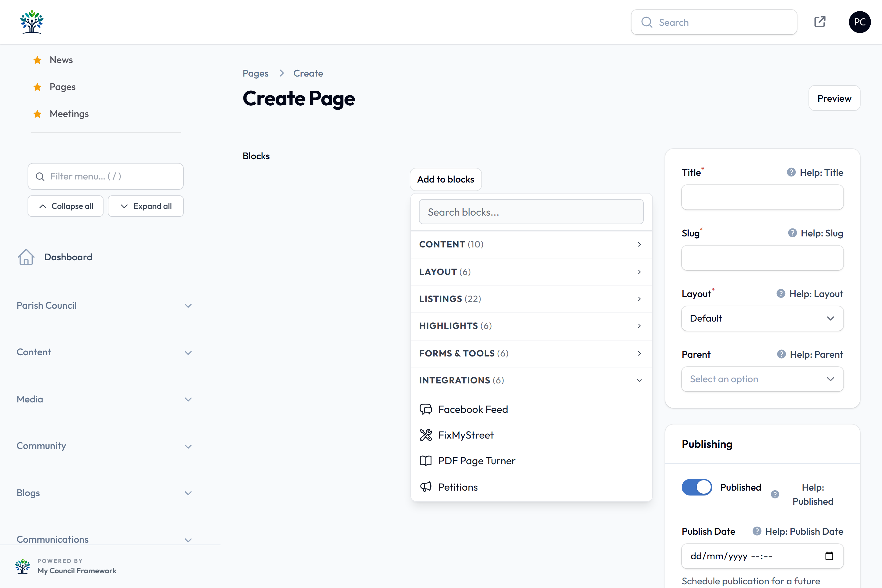
To add a block to a page, see Adding blocks.
The blocks in the Integrations category are:
- Facebook Feed
- FixMyStreet
- Mobile App QR Code
- PDF Page Turner
- Petitions
- Planning Applications
- Virtual Tour
Every block on this page only appears in the picker when its feature is switched on. Turning a feature off removes the block from the picker. Most switches are under Settings > Modules. The Facebook Feed and Petitions switches are under Settings > Advanced, which only super administrators can open.
Facebook Feed
Shows recent posts from your Facebook page, using Facebook's own page box.
| Setting | What it does |
|---|---|
| Facebook Page URL | The full address of your Facebook page, such as https://www.facebook.com/YourParishCouncil. Required. |
| Embed Code (alternative) | If the feed shows empty, paste the embed code from Facebook here instead. On your Facebook page, select …, then Embed, and copy the code. This replaces the automatic feed. |
| Heading and Show Heading | A heading above the feed. It is hidden by default. |
| Tabs to Show | Which parts of the page to show: Timeline (posts), Events and Messages. Only the timeline is ticked by default. |
| Width and Height | The size of the feed. The defaults are Medium (500px) wide and Medium (600px) tall. |
| Alignment | Left, Centre or Right. Centre is the default. |
| Show Cover Photo, Show Friend Faces (Facepile) and Use Small Header | Change how the top of the feed looks. The cover photo and friend faces are on by default. |
The Facebook Feed Block feature is off on new sites. Only a super administrator can switch it on, under Settings > Advanced.
When you use Embed Code (alternative), the tabs, size, cover photo, friend faces and header settings have no effect. Only the heading and alignment still apply. You still need to fill in Facebook Page URL.
FixMyStreet
Shows recent problems reported on FixMyStreet for your area, such as potholes and broken street lights. Each report can show a small map and photos, with a link to the full report on FixMyStreet.
| Setting | What it does |
|---|---|
| Heading | The heading above the reports. It starts as "FixMyStreet Reports". |
| Show Heading | On by default. |
| Number of Reports | How many reports to show. Enter 0 to show them all. This is the default. |
| Show Map per Report | On by default. Shows a small map of where each report is. |
| Show Images | On by default. Shows any photos sent with each report. |
The reports come from a feed address for your area. Enter it in Feed URL under Settings > Integrations, on the API Keys tab, in the FixMyStreet Integration section. Without it, the block shows an error message on the page. See FixMyStreet.
The website keeps a copy of the reports for up to 15 minutes. A new report may take that long to appear.
The reports and maps come from other websites. Visitors who haven't accepted Marketing cookies first see a message instead. They can select Enable Marketing and view to load it.
Mobile App QR Code
Shows your council's QR code with a heading and instructions, so residents can scan it with the My Council app. Use it to put the code on any page; the Contact Us page and the site footer have their own switches. See Mobile App.
| Setting | What it does |
|---|---|
| Heading | The heading above the code. It starts as "Use our app". |
| Instructions | What residents should do. It starts as "Open the My Council app and scan this code to see our news, events, meetings and more on your phone." |
| Say where to get the app | On by default. Adds the "Where to get the app" sentence and the store links from the Mobile App settings. |
| QR code size | Small, Medium (the default) or Large. |
| Alignment | Left, Centre (the default) or Right. |
The block shows nothing until a QR code image address is saved under Settings > Modules, on the Mobile App tab. The block is only in the picker while Mobile App Support is switched on.
PDF Page Turner
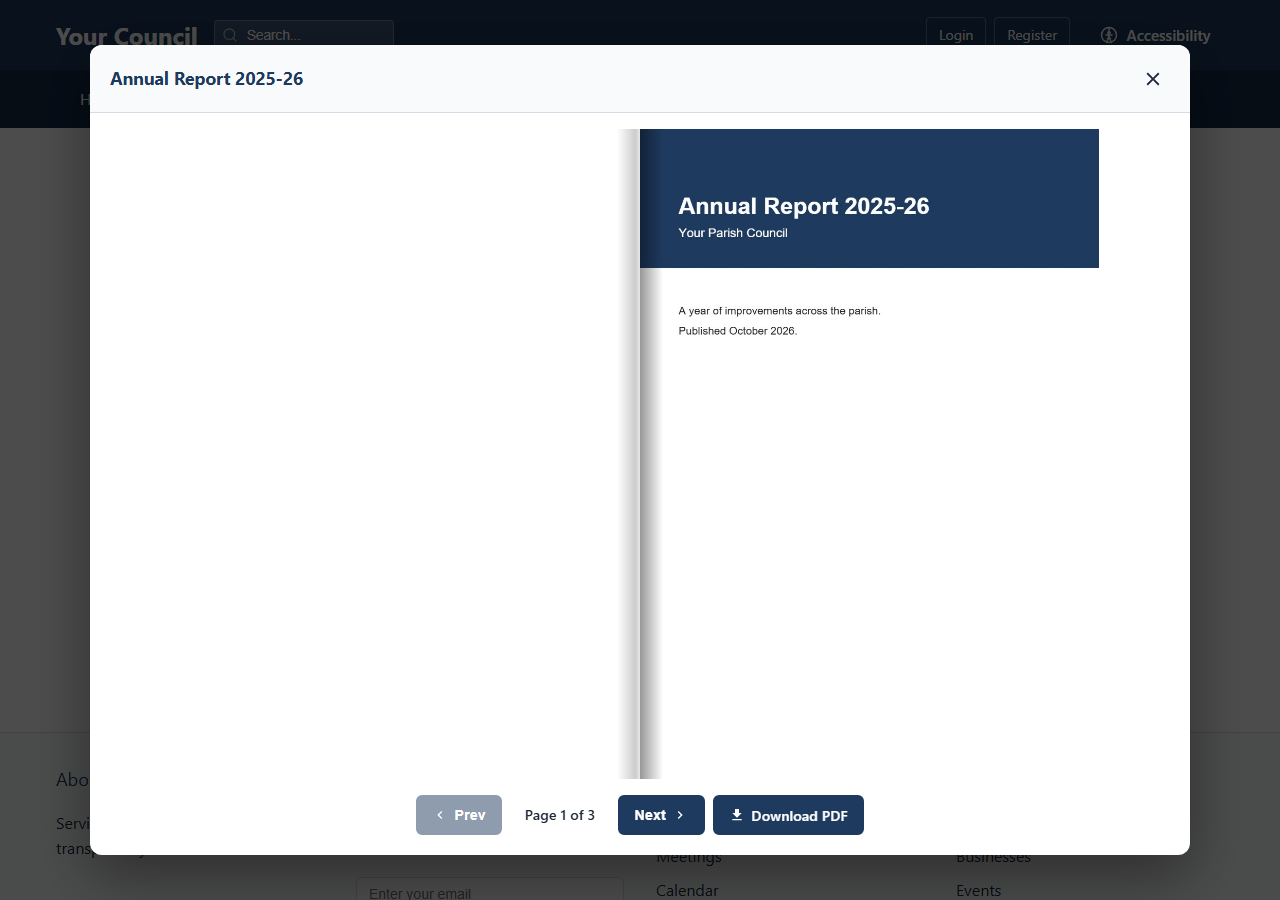
Shows a cover picture on the page. When a visitor selects it, the PDF opens in a pop-up window as a book they can flip through. Good for annual reports, newsletters and village magazines.
| Setting | What it does |
|---|---|
| Title | The heading of the pop-up window. Screen readers also use it to describe the cover. Required. |
| Cover / Thumbnail Image and Image alt text | The picture visitors select to open the PDF. Pick it from the Media Library. Required. |
| Caption | Optional text under the cover picture. |
| PDF File | Pick the PDF from the Media Library. Required. It works best with PDFs under 20MB. |
Three more sections start closed. Select one to open it.
| Setting | What it does |
|---|---|
| Image Size and Alignment | In Cover Image Display. The cover's size, from Small (200px) to Full Width, and its position. The defaults are Medium (400px) and Centre. |
| Modal Width | In Flipbook Display. How wide the pop-up window is, from Small (640px) to Full Width. Large (1100px) is the default. |
| Flipbook Height | In Flipbook Display. Short (500px), Medium (650px), the default, or Tall (800px). |
| Start on Page | In Flipbook Display. The page the book opens at. 1 is the cover. |
| Show Previous/Next Buttons, Show Page Number Indicator and Show Download Button | In Controls. All on by default. The download button lets visitors save the PDF. |
Petitions
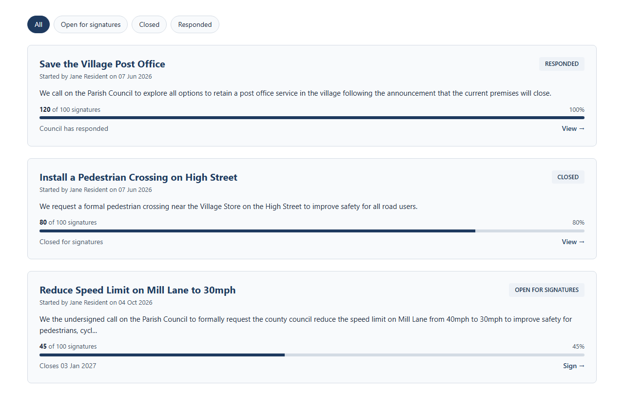
Lists your council's own petitions, with their status and a link to read or sign each one. Visitors can filter by Open for signatures, Closed or Responded. Featured petitions and those with the most signatures come first.
| Setting | What it does |
|---|---|
| Custom Heading | The heading above the list. It starts as "Petitions". |
| Show Heading | On by default. |
| Layout | Card Grid (3 columns), the default, Card Grid (2 columns), Card List (single column), Compact List or Timeline. |
| Limit | How many petitions to show. Enter 0 to show them all. This is the default. |
| Show Pagination | Off by default. Splits the list into pages, using Limit as the number per page, or 12 if the limit is 0. |
| Only show petitions open for signatures | Off by default. Hides closed and responded petitions, and the filter buttons. Useful for a short list on your home page. |
The Petitions feature is off on new sites. Only a super administrator can switch it on, under Settings > Advanced. Petitions are managed under Community > Petitions.
Planning Applications
Lists planning applications in your area, with a map, the decision status of each and filters for status and date.
| Setting | What it does |
|---|---|
| Heading | The heading above the list. It starts as "Planning Applications". |
| Show Heading | On by default. |
| Planning Search ID (override) | Optional. Leave blank to use your site's planning area. Enter a different Search ID to show another area on this page only. |
| Applications per Page | How many to list on each page. The default is 20. Enter 0 to show them all. |
| Show Map | On by default. A map of every application that matches the visitor's filters. |
| Show Status Filters | On by default. Lets visitors filter by decision status. |
| Show Date Filter | On by default. Lets visitors filter by the date the application was validated. |
| Default Filter | Which applications show first: All Applications, the default, Awaiting Decision, Approved or Refused. |
Your site's planning area is the Search ID under Settings > Integrations, on the API Keys tab, in the Planning Applications section. Without it, or an override on the block, the block shows an error message. See Planning.
The applications and map come from other services. Visitors who haven't accepted Marketing cookies first see a message instead of the list. They can select Enable Marketing and view to load it. The website keeps a copy of the applications for up to an hour, so new ones can take that long to appear.
Virtual Tour
A Google map of your parish beside a Street View panel. Visitors select a marker on the map to look around that spot in Street View.
| Setting | What it does |
|---|---|
| Heading | The heading above the tour. It starts as "Virtual Tour". |
| Show Heading | On by default. |
| Map Height (px) | The height of the map and the Street View panel. The default is 500. |
| Show Parish Boundary | On by default. Draws your parish boundary on the map. |
| Points of Interest | The markers on the map. Select Add Point of Interest for each one. |
Each point of interest
| Setting | What it does |
|---|---|
| Name | The name of the place, such as "Village Hall". Required. |
| Latitude and Longitude | Where the marker goes. Both required. |
| Pin Colour | The marker's colour. Red by default. |
| View Heading (°) | Which way Street View faces at first: 0 is north, 90 east, 180 south and 270 west. |
| View Pitch (°) | How far Street View tilts at first: 0 is level, a positive number looks up and a negative number looks down. |
Typing coordinates is fiddly. Clerks and super administrators see an Enable edit mode button above the tour on the live page. Select + Add point of interest, click the map, turn Street View to face the right way, then select Save point of interest. See Virtual Tour.
The tour needs a Google Maps API Key under Settings > Integrations, on the API Keys tab, in the Virtual Tour section. It also needs your parish centre under Settings > Site Settings, on the Location tab. Without these, the block shows an error message.
The map and Street View come from Google. Visitors who haven't accepted Marketing cookies first see a message instead of the tour. They can select Enable Marketing and view to load it.